

The South African Weather Service (SAWS) has issued multiple severe weather warnings for central parts of the country and KwaZulu-Natal, as a cold front accompanied by a cut-off low sweeps across several provinces, bringing snow, damaging winds and disruptive rain.
The warnings, valid from Sunday 9 August through Tuesday 11 August, affect the Free State, Western Cape, Northern Cape, Eastern Cape, southern parts of Gauteng and Mpumalanga, and the interior of KwaZulu-Natal.
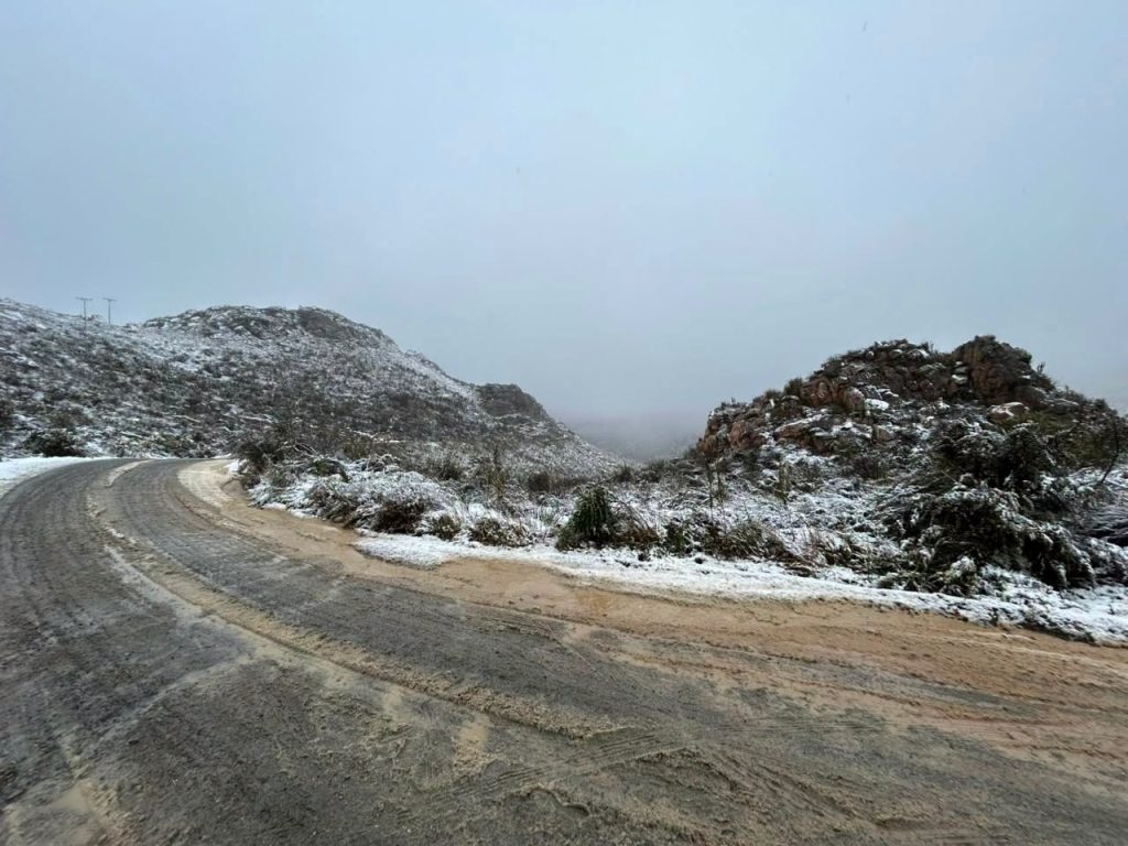
Swartberg Pass closed until further notice
The Swartberg Pass remains closed to all traffic from both the Oudtshoorn and Prins Albert sides until further notice, as snow has made the pass extremely slippery.
According to the Garden Route District Municipality, the closure was issued on 9 August at 14:35. This was later confirmed by the Western Cape Government at 16:00, with a notice from Western Cape Minister of Infrastructure Mr Tertuis Simmers and Head of Department Adv Chantal Smith, who urged the public not to travel to the pass despite the temptation to see the snow.
“Stay away from the area and prioritise your safety,” the Western Cape Government notice read.
The Swartberg Pass connects Oudtshoorn in the Klein Karoo to Prince Albert in the Great Karoo. The 27 km gravel road, with its steep zigzags and stone retaining walls, was built by renowned engineer Thomas Bain. It is set within a UNESCO World Heritage Site featuring dramatic rock formations, making it one of South Africa’s most spectacular mountain passes.
Disruptive snow expected across Eastern Cape and beyond
According to SAWS, an orange level 6 warning for disruptive snow has been issued for the Chris Hani District, Senqu, Elundini and Matatiele municipalities of the Eastern Cape until Tuesday.
The snow is expected to disrupt livelihoods and traffic, and leave some communities temporarily inaccessible.
A yellow level 2 warning for disruptive snow has also been issued for several Eastern Cape municipalities including Dr Beyers Naude, Blue Crane, Raymond Mhlaba, Amahlathi, Intsika Yethu, Dr AB Xuma, Mhlontlo and Mzimvubu, as well as east and south of the Free State along the Lesotho border and western parts of KwaZulu-Natal. Localised traffic disruptions, isolated loss of livestock and crops and disruptions to services are expected.
According to the AfriWx regional forecast, light snowfall is also expected in the south of Gauteng on Monday evening, over the southern Highveld and escarpment areas of Mpumalanga, in the eastern and northern parts of the Free State, and over the north-eastern parts of the Western Cape.
Damaging winds along KZN coastline
According to SAWS, yellow level 4 warnings have been issued for damaging winds and waves along the KwaZulu-Natal coastline, with disruption of small harbours or ports, danger to navigation, disruption of coastal activities, damage to infrastructure and settlements and injuries and danger to life from flying debris expected.
A separate yellow level 4 warning covers the KZN coast and north-eastern adjacent interior for damaging winds that could damage settlements and cause injuries from flying debris.
A yellow level 2 warning for damaging winds has also been issued for the Joe Gqabi District of the Eastern Cape, central and eastern parts of the Northern Cape, the Free State and the extreme western parts of the North West.
Disruptive rain and thunderstorms in several areas
According to SAWS, a yellow level 2 warning for disruptive rain has been issued for the Nyandeni, Port St Johns, Ingquza Hill and Bizana municipalities in the Eastern Cape, and the extreme southern and western parts of KwaZulu-Natal, with localised flooding of susceptible settlements, roads and bridges expected.
A yellow level 2 warning for severe thunderstorms has been issued for the extreme southern parts of the North West, north-eastern parts of the Free State and southern parts of Gauteng, with localised damage to infrastructure, settlements, property, vehicles and livestock possible.
Cold front and cut-off low to persist into Tuesday
According to SAWS, the public and small stock farmers are advised that very cold and windy conditions, snowfall over mountainous areas and rough to very rough seas can be expected as the cold front and cut-off low persist into Tuesday. Farmers and the public are urged to take the necessary precautions.
Provincial weather forecast for Monday 10 August 2026
Gauteng: Cloudy and cold with scattered showers and thundershowers. Light snowfall possible in the south in the evening.
Mpumalanga: Cloudy and cold to cool with scattered showers and thundershowers. Light snowfalls over the southern Highveld and escarpment in the evening.
Limpopo: Fine in the morning, otherwise partly cloudy and cool to warm with isolated showers and thundershowers, scattered in the south-east.
North West: Partly cloudy in the east, otherwise cloudy, windy and cold to cool with isolated showers and thundershowers, scattered in the extreme south-east.
Free State: Cloudy, windy and very cold to cold with scattered showers and thundershowers. Possible snowfall in the eastern and northern parts.
Northern Cape: Fine in the north, otherwise partly cloudy, windy and cool to cold, very cold in places. Isolated showers and thundershowers over the east and central parts with light snowfall in the south.
Western Cape: Cloudy and very cold to cold, cool over the West Coast District, with isolated to scattered showers except in the west. Snowfall over the north-eastern parts until the evening.
Western half of the Eastern Cape: Cloudy and cold to very cold with scattered showers and rainfall, widespread in the south-east. Snowfall over the high-lying areas.
Eastern half of the Eastern Cape: Cloudy and cold to very cold with widespread showers and rainfall, scattered in the north-west. Snowfall over the high-lying areas.
KwaZulu-Natal: Morning fog patches over the interior, otherwise cloudy and cold, very cold in the south-west with snowfall over the western high-ground. Widespread showers and rainfall expected.
Sources: South African Weather Service (SAWS), AfriWx, Western Cape Government, Garden Route District Municipality, Swaicsa


You must be logged in to post a comment.