
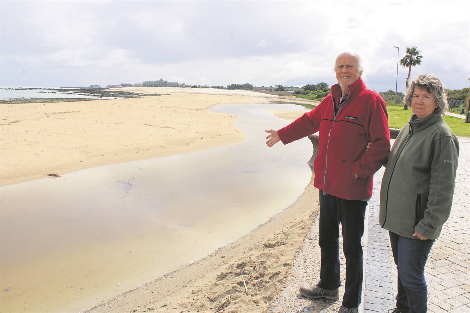
As the Gordon’s Bay dune rehabilitation project reaches its halfway stage, some residents are not convinced it was properly thought out following what they observe as loss of marine life such as prawns and perlemoen and the interruption of the river flow, which now meanders along the beach and has created a lagoon and rising sand levels.
“We’ve lived for more than 30 years in Gordon’s Bay and the sand has never been so high. The sea pushes the sand towards the beach and the south-easterly wind carries it over. The more the City dumps sand into the ocean, the more sand is being pushed back onto the beach,” said Hans Zupan as he pointed the other concerns, including constant blockages of the stormwater pipe at the beach.
The City initiated the dune rehabilitation project earlier this year (“Access to the beaches ongoing while the dunes are rehabilitated”, DistrictMail & Helderberg Gazette, 3 March 2023) and have so far initiated profiling of the beach and completed the installation of the netting, irrigation and initial planting. Currently the project is in the vegetation establishment phase. Between now and end of June next year there will be additional planting, seeding, dune fencing, and the annual management of trapped wind-blown sand that will take place. After handover of the project at the end of June, the Coastal Management Branch will continue with ongoing maintenance and management of vegetation and the wind-blown sand.
To date, 13 690 plants were searched and rescued from the site and replanted on the dune; 100 000 plants comprising of maram and coastal dune species have been planted; 90 kg of seed comprising a variety of dune species were spread by hand; and 9 500 m of nets erected.
“I’m just not convinced everything is going according to plan,” said Zupan. “The river flow has completely changed direction and is covering the main beach. Everyone in Gordon’s Bay knows the impact of the south-easter and all this sand will now be blown all over beach road and create more work to have it removed.
Coastal system is complex
But according to the Deputy Mayor and Mayoral Committee Member for Spatial Planning and Environment, Alderman Eddie Andrews, no challenges were experienced this far, other than what is expected when undertaking a dune rehabilitation project.
“Working on-coast is a complex space and system to work within, and requires one to adapt at all times,” he said, and clarified the City had environmental authorisation for the management of dunes and beaches across the city.
“There is no correlation between the work undertaken and the abundance of marine life in the area,” said Andrews, who elaborated that the sand that is pushed into the near shore will be redistributed on the beach by coastal processes. “Marine resource extraction over the years has reduced the abundance of species on this section of coast. Returning sand into the environment may have had a short-term impact, but there is no long-term impact as it is not unusual for sand to move around in this environment covering and exposing sections of the rocky shore.
“In False Bay, the beach profiles thicken in winter, and this sand is then distributed along the coast by the prevailing south-asterly winds. This is what is experienced at Gordon’s Bay, and prior to the dune project this sand would have blown into the migrating dunes adjacent to Hendon Park and Harbour Island, where the sand is lost from the system as it gets trapped in the adjacent infrastructure. The implementation of the dune project has allowed this wind-blown sand to be managed, trapping it in the fore-dune area where it is more easily returned to circulation after summer,” he said.
Grass area inundation equals poor-quality recreational space
“Notwithstanding the impacts of the wind-blown sand, the primary reason for lowering the beach at Gordon’s Bay, similar to what was undertaken last season, is to reduce the wave run up and overtopping of the sea water onto the adjacent recreational space and grass areas.
“The grass areas don’t take well to seawater inundation resulting in a poor quality recreational space. For this reason the beach profile is lowered to minimise the impacts of the wave run up on the grass areas, recreational space at the back of the beach. Simply put, the work will also ensure a more pleasant environment for recreational users.”
Andrews added that although it is not intended to lower the beach more frequently this is monitored, and if required could be undertaken again, depending on resources and the impacts of the thickened beach profile.
When it comes to the meandering of the river across the beach, Andrews stated this is determined by the beach profile which is governed by coastal processes. “If there is flooding upstream as a result of the lagoon forming or an impact on adjacent coastal infrastructure the City would likely intervene as required. And when it comes to the stormwater pipe this is constantly monitored by the City’s Roads and Stormwater Department, in consultation with Coastal Management, which ensures the infrastructure functions as it should.”


